
UPDATE: The National Weather Service issued a Severe Thunderstorm Warning for Orange, Durham and Chatham Counties on Monday, set to last through 6:45 p.m. The initial tornado watch expired with no reports of any tornado touching down within the region.
As a band of strong storms sweeps across the eastern U.S. on Monday, the Research Triangle and the rest of the Piedmont are bracing for high winds and the chance of tornado development.
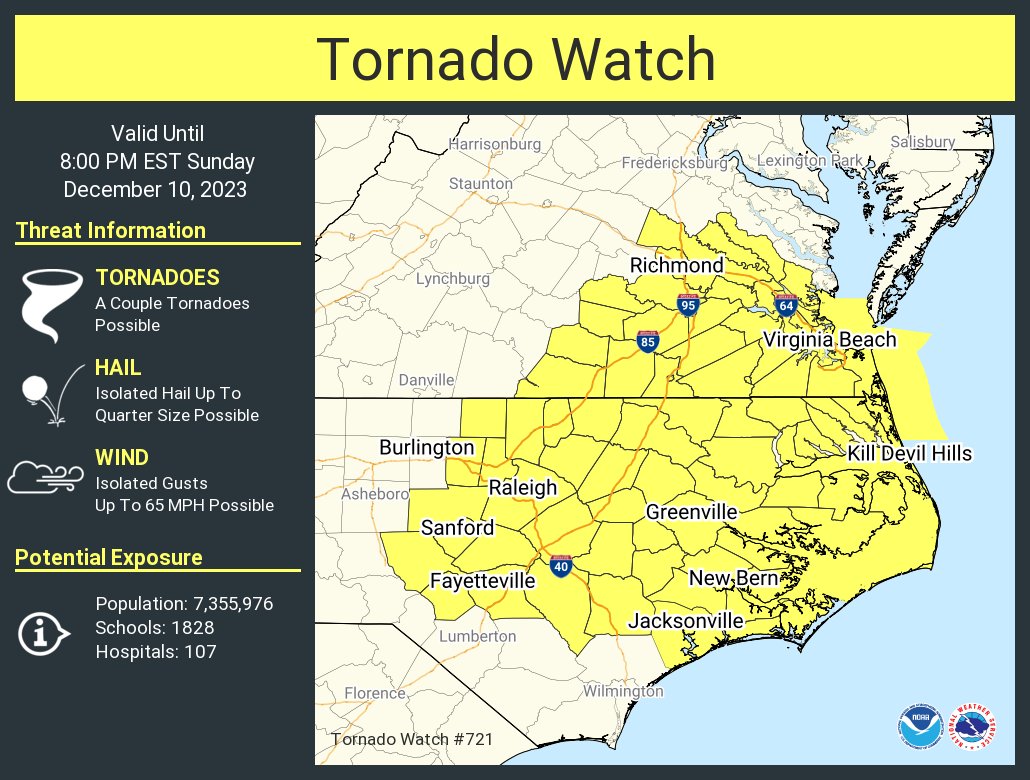
The National Weather Service issued a Tornado Watch for all of central North Carolina Monday morning to last through 2 p.m., saying it is “likely” that several tornadoes appear as the storm passes through and widespread gusts of wind up to 85 miles per hour are expected.
“Today will be a stormy day for sure, with multiple rounds and waves of thunderstorms sweeping across the area,” said Jonathan Blaes with the National Weather Service in Raleigh. “The greatest threat for damaging winds, which is really what our biggest worry is today, is likely to range from mid-day into mid-afternoon — so, like, from 12 p.m. to 4 p.m.”
Blaes said the presence of storms overnight and in the early morning reflects how “charged” the atmosphere is and complicates the forecast, since severe conditions could develop faster from the existing storm cells. He added that while the high winds will be far more widespread than the chance of tornadoes, people should be prepared for them and aware if they are planning on being outside for extended periods of time.
Based on the storm’s movement, central North Carolina falls in a Level 4 Risk, according to the National Weather Service’s Storm Prediction Center. The second-highest rating on the scale means there is “high confidence” that severe weather will impact the region and residents should expect severe winds and tornadoes.
Best Practices and Preparation for Tornadoes, Power Outages
If a tornado develops near you, expert recommendations are to go to a safe location you have previously identified — typically one that is away from windows and closer to the ground. Protect yourself by having an emergency supplies kit, covering your head and neck with your arms, or putting materials like furniture and blankets around you. If you are in a vehicle when you see a tornado and you cannot escape its path, stay in the vehicle with your seatbelt on and duck your body as low as possible into the seat. Avoid seeking shelter or driving under bridges.
Orange County recommends Orange County residents sign up for OC Alerts to receive updates on tornado watches and warnings, as well as other emergency alerts throughout the year. More local emergency preparedness tips can be found on the county government’s Ready Orange website. Additionally, the Town of Chapel Hill provides alerts and road closures on its Emergency Updates webpage, and the national Emergency Alert System and NOAA Weather Radio provide alerts related to severe weather.
The high winds could also create power outages from fallen trees or branches on power lines. For Duke Energy customers who experience a power outage, the energy provider recommends reporting it through the Duke Energy app, filling out this form online, texting OUT to 57801, or calling 800-419-6356. Piedmont Electric outages can be reported by texting “#out” or calling 1-800-222-3107, as well as logging into SmartHub and going to “Report an Issue.”
- Keep freezers and refrigerators closed.
- Use a generator, but only outdoors and away from windows.
- Do not use a gas stove or oven to heat your home. It increases your risk of carbon monoxide poisoning. Using an oven or stovetop can also increase the risk of fires, burns and could damage the appliance.
- Disconnect appliances and electronics to avoid damage from electrical surges.
- Have alternate plans for refrigerating medicines or using power-dependent medical devices.
- Check with local officials about heating and cooling locations open near you.
Local Government Services Impacted
Out of caution for the safety of its staff and residents, the Orange County government suspended non-essential and in-person services starting at 12 p.m. on Monday. That means all county offices and the Orange County Transportation system would not be available for the rest of the day. Essential services — including the county’s emergency services and law enforcement — will continue to operate according to the alert.
Additionally, the Orange County court system closed down at 12:30 p.m. out of concern for the weather forecast. In Carrboro, the town also closed its town tall, the Drakeford Library Complex and the Carrboro Century Center at noon.
For later on Monday, after the storm has likely passed, the Orange County Partnership to End Homelessness will be activating its white flag overnight shelter at 828 Martin Luther King Jr. Boulevard in Chapel Hill due to forecasted temperatures below freezing. Because of the severe weather risk, the shelter will open one hour earlier than normal — welcoming any who need a sleeping cot and meal at 6 p.m. and running through 7 a.m. on Tuesday.
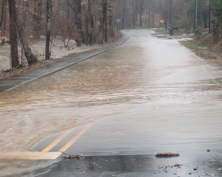
Featured photo via Tanya Gorelova.
Chapelboro.com does not charge subscription fees, and you can directly support our efforts in local journalism here. Want more of what you see on Chapelboro? Let us bring free local news and community information to you by signing up for our newsletter.


