“Viewpoints” is a place on Chapelboro where local people are encouraged to share their unique perspectives on issues affecting our community. If you’d like to contribute a column on an issue you’re concerned about, interesting happenings around town, reflections on local life — or anything else — send a submission to viewpoints@wchl.com.
Let’s Complete Carrboro’s Greenway and Connect Our Schools, Parks and People
A perspective from Melody Kramer and Alyson West
Over the next several months, Carrboro’s Town Council will be soliciting public comment on completing the next stages of the Bolin Creek Greenway.
We’re thrilled that we are starting this community-wide conversation.
If you’ve just moved to Carrboro – or don’t routinely follow council meetings – here’s a short synopsis:
In 2009, the Carrboro Town Council approved a conceptual master plan to build out a greenway network across Carrboro. The conceptual plan outlined common goals, listed existing connections across the town, and recommended that each part of the greenway (numbered 1-4) be implemented in phases. Funding for each phase has been separate. Here’s a timeline of the work so far:
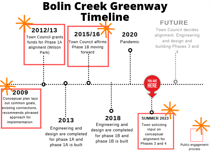
Right now, our greenway system is not complete — there are bits and pieces that have been completed, like the multi-use path in Wilson Park (Phase 1A) and the path between Homestead Road and Chapel Hill High School (Phase 1B). In each phase, the Town Council solicited public input, agreed on an alignment, and then solicited engineering and design input.
Town Council is about to solicit public input for Phases 3 and 4, which would connect the existing small bits of our island-like greenways sections to a larger network. Phases 3 and 4 would go along the existing OWASA sewage corridor along Bolin Creek, and eventually connect to Bolin Creek Trail in Chapel Hill.

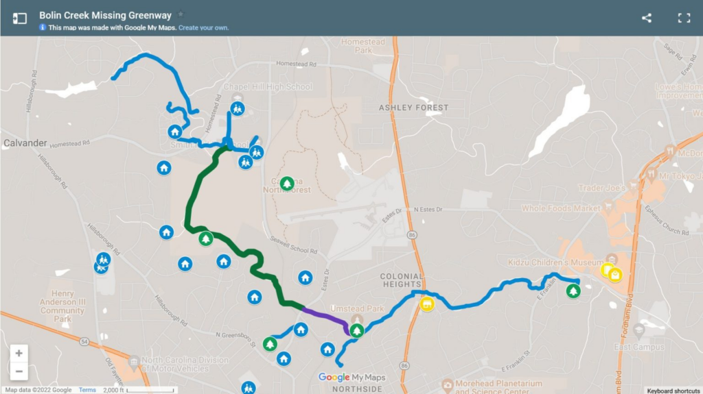
The green part of this map is what would be built and connect the blue parts (which already exist).
If you’ve walked along Bolin Creek Trail in Chapel Hill, or along the Riverwalk in Hillsbourough, or along greenways in Raleigh, Apex, Durham, Cary, Charlotte, or hundreds of other places across North Carolina and United States, you know the benefits:
- Greenways provide equitable access: Greenways make it possible for strollers, wheelchairs, feet, walkers, and bikers to enjoy nature, get across town, and make many 1-3 mile trips without needing a car. The proposed greenways would be accessible for those in wheelchairs and strollers, and provide protected, safe biking and walking routes for all communities in Carrboro, including residents of:
- The Landings at Winmore
- Bolinwood Condominiums and Estes Park Apartments
- the Oakwood complex
- Craig-Gomains housing complex
- Greenways benefit our environment: They reduce car travel, and keep people on a path, which helps reduce sedimentation in the creek and repair the creekbed, a vital part of our ecosystem. (Our human activity along the creek has created informal or “braided” trails along an ever-widening network of mud puddles. The footpaths we’ve created have been expanding into the forest and up to the creek’s edge, which degrades vegetative buffers and increases runoff into the stream.)
- Greenways can mitigate the impacts of flooding: As this blog post from Mecklenberg County, NC points out, “Greenways are often built in floodplains or areas along creeks and rivers that are likely to experience repeated flooding. These trails serve as buffers or “no build” zones. These buffers store excess stormwater runoff and protect surrounding natural areas that are able to absorb flood waters and filter stormwater pollutants. The natural vegetation in these buffer areas also helps reduce the chance of erosion and moderate water temperatures. And they provide natural habitats for wildlife like this blue heron spotted on McAlpine Creek Greenway.”
- Greenways connect communities and kids: The greenway in Carrboro will connect over 40 neighborhoods in Carrboro. It will allow more students to bike and walk safely to school, and reduce idling car lines outside of our middle schools and high schools. The proposed greenways would provide protected, safe biking and walking routes for:
- Chapel Hill High School
- Smith Middle School
- Seawell Elementary
- Carrboro High School
- Morris Grove Elementary
- Northside Elementary
- Greenways are great for getting people around town: Replacing 1-3 mile trips by car with those by foot or bike transforms the carbon footprint of a community, while allowing people to get exercise and health benefits in a safe, accessible way.
Why a greenway in the sewage easement makes sense
The proposed Bolin Creek Greenway would go along the existing 30-foot-wide OWASA sewage easement that is already cleared of trees so OWASA vehicles can get through. Erosion is rampant along the existing creek — but a greenway project can include both anti-erosion measures and creek restoration.
The easement that was designed and installed along Bolin Creek in 1965 was meant to harbor a large pipe that moves poop – it was not designed to be the incredibly popular recreational trail that it has become in the last several decades, and there are some destructive consequences that result from that — including increased runoff and sedimentation into the stream, and a surface that is functionally impervious. (That means that it’s not allowing water to soak into the ground.)
Building a greenway along an existing sewer easement along the creek means a path can be designed with a minimum of tree clearing, while the erosion that pedestrian and OWASA truck traffic are already causing can be improved through bank restoration and keeping pedestrians in designated areas. And luckily, Chapel Hill has already provided us with the opportunity to study potential effects on wildlife and streamflow data— we know that wildlife and streamflow data have been unaffected by a greenway on the very same creek.
There are so many reasons why connecting our greenways makes sense — both for our families now and families who will live in Carrboro and Chapel Hill in future generations.
Let’s build a sustainable, accessible path for all of Carrboro
In its current condition, the OWASA easement is not good for many in our community who can’t navigate the roots and puddles, and it’s not good for Bolin Creek. We are not managing the impact of the high volume of activity on the easement, on the creek and on the environment, and the informal path is not usable for everyone.
When people are unable to navigate the trail, they are simply excluded from the entire greenway, and Carolina North Forest in general. The status quo is excluding members of the public from accessing public space and it is harming our creek. Installing a durable, hard surface that can withstand flooding, along with wayfinding and public access points, will make this sewer easement into a truly great public park, a linear park, for all.
Join us at the Carrboro Linear Parks Project. We’re working to build connected, accessible greenways in Carrboro that will connect our schools, parks and people — and make Carrboro a better place to live for generations to come.
“Viewpoints” on Chapelboro is a recurring series of community-submitted opinion columns. All thoughts, ideas, opinions and expressions in this series are those of the author, and do not reflect the work or reporting of 97.9 The Hill and Chapelboro.com.
The Bolin Creek trail in Chapel Hill is one of my favorite things about living here. Extending it to Carrboro would be a game changer for our community, giving us a chance to show our commitments to the environment and equitable access for all.
I am so eager to have this move forward. I got excited when they completed the Wilson park section, and I’ve been (possibly impatiently) waiting for the rest for years. It’s really making me happy to see posts like this one that show how eager many of my neighbors are, too.
Melody/Alyson – I appreciate the article and open discussion of greenways in Carrboro. I have a difference of opinion. The difference is not whether greenways have a place in the community but, rather, the manner in which they are implemented and how they can best serve the diverse needs of the community. The decision about how we implement greenways will have profound impacts on who benefits from this capital investment, costs to the town, environmental impact to our forest and whether future transportation needs will be met. The reason I take issue with both the timing and scope of this community engagement is because there are a significant number of challenges (engineering, regulatory, environmental, land use) to paving Bolin Creek that are not being communicated. Further, despite the presence of multiple alternative routes, including the off-road protected side path connecting Estes Drive to Homestead Road via Seawell School, town council has, so far, refused to acknowledge or educate residents about these options in the context of this engagement. It is confounding to many of us since these alternative routes would be less costly to the town, less environmentally impactful and would provide more equitable access for safe biking, walking and traveling throughout the community. I know we disagree on this point and don’t want to litigate it on this thread but wanted to communicate how some of us in the community feel on the issue.
Yes, we have examined many of the issues you’ve mentioned – because they’ve been used to stall this project for the past 15 years. I would highly encourage people rely on primary sources for this. Here are some:
Here’s a Town of Carrboro staff memo, written in conjunction with OWASA, UNC and environmental experts, which assesses the greenway and the environmental, regulatory, and land use concerns. It concludes that the easement is essentially impervious. Greenway opponents often cite research about the negative impacts of locating pavement next to streams, but also carefully elide the fact that we have a 30-foot wide impervious path next to the creek right now. A major argument for co-locating the greenway with the sewer easement is that doing so would actually shrink the total amount of impervious surface along the creek because in dedicating ten feet to pavement for trail users we can reclaim the other twenty to forty feet with seeded shoulders and other vegetation.
https://triangleblogblog.com/wp-content/uploads/2023/02/staff_memo_2009.pdf
The Seawell/Estes path you mention is not a greenway. It would not help anyone who lives along Hillsborough or Greensboro in Carrboro or the kids who could bike to middle and high school. It would not help the water quality of the creek. And it would require many, many more trees coming down – a reason that UNC said it wasn’t their preferred alignment. https://triangleblogblog.com/2023/05/15/a-side-path-on-seawell-school-road-is-not-a-viable-alternative-to-completing-the-bolin-creek-greenway/
As for engineering, there’s no reason to think this greenway would be different than any of the topologically-challenging greenways that have been created across the country and across NC. Because these questions come up so regularly, we created a FAQ which links to primary source documentation for all of these points: https://www.carrborolinearparksproject.org/learn/faq
There are pros and cons to weigh with every decision. In this case, there are many pros: easier to eliminate 1-3 mile trips, a connection to Chapel Hill’s Bolin Creek Trail which will make commuting to UNC easier for everyone who lives along the greenway in both towns, the ability to add vegetation along the riparian zone (which is currently in bad shape), helping our school traffic patterns (because if 1/4 of kids take the greenway, that’s 1/4 fewer cars in the car lines, which improves traffic patterns for everyone) and keeping people on a small path to protect wildlife and fauna.
The EPA points to ecological restoration efforts in Wake Forest, where efforts to create a greenway went hand in hand with improving the riparian buffer, erosion control, and stormwater control measure.
Hi Melanie – Thank you for the response. To your comments above, my general point is I can see no legitimate downside to having all of this information (including all alternative routes) transparently presented to citizens. The benefit of this approach is it allows all of us to make an informed decision with the full context of the options available to us. None of the proposals are all good or all bad, they each have their own compromises. While I don’t ascribe any malicious intent to the organizations that you and Alyson are a part of, I think it’s best to let each citizen decide instead of organizations who may have their own reasons for pushing certain options over others.
Hi Drew – my name is Melody. The engagement process hasn’t started yet. From the Feb. meeting, we know that the council is starting the engagement process this summer (and from a question you asked at a recent council meeting, that it’s starting soon.) That’s expected to wrap up by October. https://triangleblogblog.com/2023/02/14/liveblog-carrboro-town-council-work-session-february-14-2023/
I’d agree with you that everyone can make up their own mind about what’s best for the town with respect to this greenway, and there is certainly a lot of information available already from the town and local advocacy organizations. But I think it’s important for anyone reading your comment to also understand that it’s not a referendum that will decide the final alignment for Phases 3 & 4 — it is going to be a vote by seven elected officials. The current public engagement effort, therefore, is aimed at helping the town council make a decision by gathering additional feedback from the community.
The 2009 plan had extensive public engagement and the final report incorporated all the arguments we hear both for and against the greenway today. Those points of view — that is, the positions of informed advocates on both sides of this issue — are well understood by the town council already. I believe what council wants to understand better before making a decision is how OTHER people feel about the greenway, people who are often excluded from traditional “opt-in” public engagement efforts. So I guess I would not be surprised to find that the upcoming public engagement doesn’t default to the HOAs around the creek like it has in the past.
Bolin Creek Trail shouldn’t replace a safe bike and sidewalk on Estes Drive and Seawell School Road that would serve all residents in Carrboro and Chapel Hill, connect communities and kids. We tried the proposed trail from Wilson Park in Carrboro to Smith Middle School. It is a wonderful recreational nature walk, but definitely not a trail that can be used as a daily commute route to the Elementary, Middle or High School, not with a bike or by foot. Some parts would loose their appeal, some would be improve and get safer and more accessible. But just the length and location would mean a huge detour and not an alternative for a lot of families try to reach one of the schools from the south and east. With school bus routes cancelled on a daily basis, a side walk for pedestrians and bikes would be a great alternative for students getting to school, commuters to work and make residents along more connected.
It wouldn’t replace anything – and there are no plans to add sidewalks to the part of Estes between the circle and Seawell, so anyone living below the circle (along Greensboro and Hillsborough and throughout Carrboro) wouldn’t be able to get there. The Seawell/Homestead path serves one population, but wouldn’t serve many people in Carrboro – and would get at the other additional benefits of the greenway (namely restoration of the creek, providing a carless path for people of all ages and mobility levels, connecting to a larger network within Chapel Hill.)
I’ve biked with my school-aged kids from Umstead Park to the Community Center Park along the Bolin Creek Greenway in Chapel Hill, and it takes us about 15 minutes. Biking from Wilson Park to Smith Middle would take about the same amount of time on a paved trail if we extended the greenway into Carrboro. Seawell School Road is too dangerous to get to for people coming from the south, and there’s not any realistic plans to build a connection (you’d have to work with the railroad, for starters, and they rarely cooperate). You can read more here: https://www.carrborolinearparksproject.org/learn/faq#h.wksk8a4rsknx
Like I said it shouldn’t replace the plan to build sidewalks on Estes. I am not against the Bolin Creek project. But there is only an amount of money, time and staff to plan this projects. If I would have to decide between this two projects, I would prioritize a separate sidewalk on Estes and the missing part of Seawell School Road. The sidewalk coming from Estes up Seawell Road stops a bit after Hanover and starts again after Seawell Elementary. This doesn’t make any sense, especially this part with the blind curves needs a sidewalk. A separate sidewalk is safer than walking or biking on the street.
Having three schools next to each other not connected with any sidewalk from the main street is a no-go.
We bike and walk regularly on Bolin Creek Trail from Carrboro (via Umstead Park), it is a great safe path and we waited eagerly for it to be finished (especially the tunnel under MLK). But we only use it for recreational purpose. You have to take the detour over Wilson Park, what leaves you still with an unsafe part of Estes Drive. Probably one reason why Bolin Creek Trail is mainly used by pedestrians, what the project website says?
The three schools are on top of a hill, you have very steep parts, especially the last third that would connects the schools. Bolin Creek Trail in CH is mainly flat (except the part that connects Northside/downtown CH, but still flatter than Carrboro). You can see the elevation on maps, we experienced it biking and walking both trails. Seawell School Road is less steep.
Another problem in Carrboro and Chapel Hill is that a lot of greenways, sidewalks, bikepaths are not connected to each other. You can see people riding their car to a greenway, park, and then walk or bike from the lot, because there is no safe connection, what adds to more car traffic. Or the sidewalks just stop in the middle of nowhere (like on Seawell Road). It is improving and there are many great outreach projects from both towns, but still a long way to go. The suggested trail must have accessible entry points, otherwise it can’t be used by everyone.
Yes, I completely agree. At their meeting on April 20th, the Chapel Hill Town Council approved a $500k ARPA allocation for town staff to design an extension of the existing Bolin Creek Greenway in Chapel Hill from Umstead Park to Estes Drive in Carrboro. Town staff evaluated a number of projects for the town’s “everywhere to everywhere greenways” program, and found that extending the Bolin Creek Greenway to Carrboro checked all the right boxes for feasibility, equity, and impact. The motion to approve the funds passed unanimously and there was not a single public comment against extending the greenway along Bolin Creek.
This would then connect to the Carrboro network. You can read more here: https://triangleblogblog.com/2023/04/21/chapel-hills-actions-to-extend-the-bolin-creek-greenway-increase-the-urgency-of-carrboros-proposed-extension/
Very good points Lisa. The only entrance to the proposed Bolin Path in carrboro is down a small residential neighborhood and would have 15 spots. Not terribly accessible. The other access point would be Umstead Park and the schools (but you cannot be there or park for recreation during school hours, as it should be) so yes, paving in the woods would be very limited in terms of getting on or off. Links on roads are more accessible to everyone.
That’s not true, and not what was in the master plan. Wilson Park (with 100 spots) and the high school (on weekends) are both proposed. There are a few entrances proposed on the master plan, which you can see here: https://triangleblogblog.com/wp-content/uploads/2023/01/BCG-Ch4-ProposedDesign_201408050852158212.pdf (This is from the master plan.) Also, the existing lots at the other entrances, and folks from across Carrboro would enter on foot/bike.
Hi Melody and Alyson,
The picture that you all included in this article of the eroded part of Bolin Creek trail is not where the greenway would go. The part you have taken a picture of is a natural spring that is almost always that muddy after any amount of rain, which is separate from the very real issues of erosion along the creek. This is also where the OWASA lines run and OWASA has made it clear that they are not OK with paving going on top of their infrastructure. This would require the greenway to go through the forest which would increase the amount of erosion because it would require some amount of clear cutting. I believe the town as well as the Carrboro linear parks project is grossly underestimating the scope and cost of actually addressing the erosion issues along Bolin Creek. This is going to cost a lot of money, which will likely increase taxes and most impact the folks you are purporting helping. We absolutely need to figure out how to make biking safer and have more spaces be accessible to folks. I don’t think that paving this particular green space is the answer because I don’t actually think that it’s truly as accessible as it’s being stated (show me where the accessible parking/trail entryways will be along this trail) and it’s not really connected to places where people who are not hard-core cyclists would actually bike to. I think there are other places where money for greenways/protected bike paths could be more accessible and more useable than what is being proposed now.
Hi Sam, I’m on the OWASA board and my understanding is that this would go in the existing easement, as it does in Chapel Hill, Hillsborough, and many other locations. People can learn more here:
https://triangleblogblog.com/2022/11/21/your-poop-%F0%9F%92%A9-and-bolin-creek/
Sam,
The photo is absolutely where the trail would go through with the preferred alignment, which is at the Tripp Farm bridge. This is evident from the maps in the conceptual master plan.
OWASA has not said it wouldn’t allow the greenway on top of the easement. In fact, OWASA ok’d the preferred creekside alignment at a meeting back in 2009 and this is also noted in the conceptual master plan. The Bolin Creek Greenway in Chapel Hill is on an OWASA easement, as is the Booker Creek and Morgan Creek greenways. Greenways co-located on sewer utilities is very common.
Regarding cost, greenways are funded (typically) through federal funds with a match from the local government. Carrboro also passed a greenways and sidewalks bond in 2003, so that is another option. The conceptual master plan describes how, because the project is both transportation and environmental in nature, the town could apply for funding reserved for environmental remediation. You can refer to how the town is funding the Morgan Creek Greenway.
Hardcore cyclists are not interested in the greenway because (as a hardcore cyclist myself) greenways are not very hardcore. People mostly walk on greenways. We know this from statistics on the Chapel Hill greenways. This greenway would connect three school sites to a wider, soon-to-be regional greenway network. The list of destinations it would connect when fully built out are too many to list.
The 2009 staff memo answers a lot of the points you raise. I’d have a look at that: http://www01.townofcarrboro.org/BoA/Agendas/2009/12_08_2009_D3A.pdf
There’s a new euphemism for rezoning by Pam Hemminger called “Gentle Density”…A veritable oxymoron and almost seems like an evasive terminology for invading neighborhoods with unwanted new housing. How I wish all those who approved the monstrosity of the behemoth on Ephesus Church Road would all gather and behold the colossal eyesore they approved before they all step further into the abyss of total ruination for Chapel Hill.. Don’t even get me started on Aurora…It’s already a nightmare and it’s embryonic.
As former chair ofOrange County Parks and Rec Council I support extending and completing the greenway system. However before spending the money on this Carrboro should aid the Fox Meadow community in providing access to water and sewer. Today we have a doughnut hole in the OWASA map. They use a sleight of hand in their map of where service could be provided as opposed to the true map of actual service area. Check it out.